Contents of dossiers on projects on district planning in Vietnam
What are the contents of dossiers on projects on district planning in Vietnam? – Minh Nguyet (Can Tho).

Contents of dossiers on projects on district planning in Vietnam (Internet image)
Currently, this content is guided in Circular 04/2022/TT-BXD on dossiers on tasks and projects on inter-district, district and special purpose zone construction planning; urban and rural planning. promulgated by the Minister of Construction of Vietnam.
Contents of dossiers on projects on district planning in Vietnam
(1) The drawing includes:
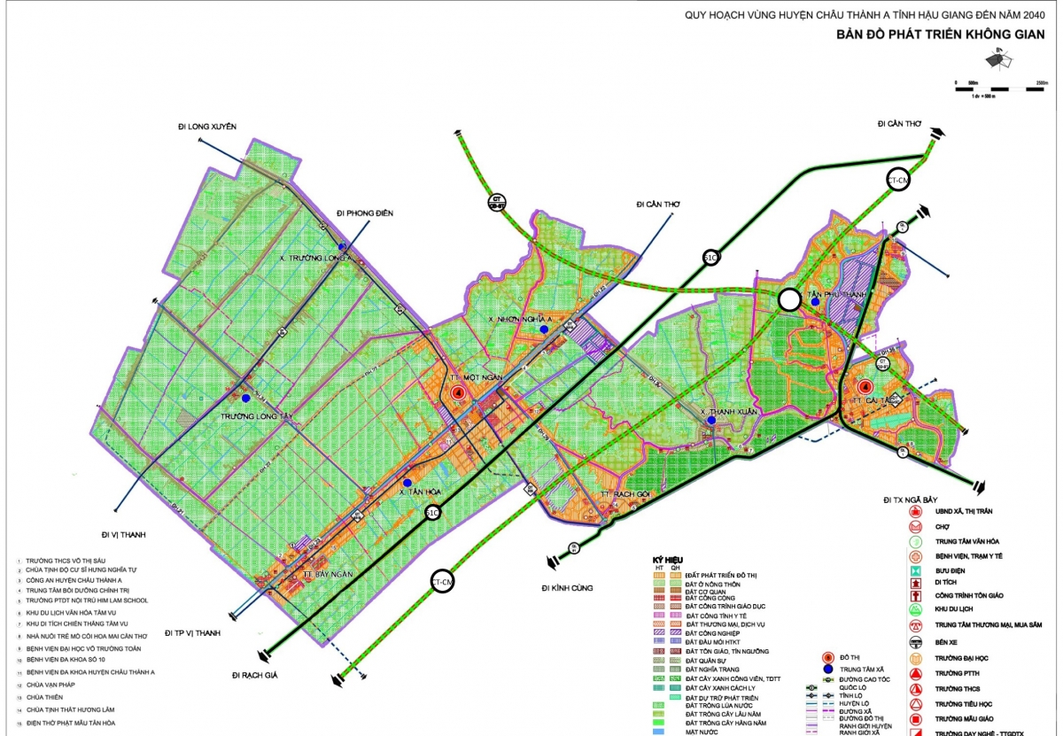
- Diagram of location and regional relationship: Location and boundary of the planned region; natural, socio-economic and environmental relationships among regions in the provincial planning that affect the planned regions.
The diagram shall be shown in the urban-rural system planning map in the provincial planning at the appropriate scale.
- Map of current status of region:
Natural conditions, current status of population distribution and land use in the planned region; current status of social and technical infrastructure systems at national, regional, provincial and district levels in district as prescribed in Appendix II of Circular 04/2022/TT-BXD. The drawing shall be shown in the topographic map at the scale of 1/10.000 or 1/25.000
- Development management zoning map: Identification of the zoned regions for management. The drawing shall be shown in the topographic map at the scale of 1/10.000 or 1/25.000
- Space development orientation map: Identification of the development space of urban areas and rural residential areas; special purpose zones at national, provincial and district levels according to regional planning, provincial planning and technical planning; security and defense areas;
Administration, commerce - services, culture, physical training and sports, research, training, healthcare center development areas at district level or higher level; commune cluster and commune center location; agricultural and forestry development areas, historical-cultural relics, scenic spots and other economic-technical establishments according to planning stages (as specified in Appendix II of Circular 04/2022/TT-BXD).
The drawing shall be shown in the topographic map at the scale of 1/10.000 or 1/25.000
- Technical infrastructure orientation map at regional level:
Identification of network, location and scale of technical infrastructure works at national, regional, provincial and district levels according to each sector, including technical preparation, traffic (down to inter-commune roads), electricity, water supply, energy supply, water drainage and wastewater treatment, solid waste management, cemeteries and passive telecommunications infrastructure.
The drawing shall be shown in the space development orientation map in combination with topographic map at the scale of 1/10.000 or 1/25.000
(2) The description includes:
- Reasons and necessity of district planning; grounds for planning; location, scale and scope of the planned region; viewpoints and objectives of the development of regions.
- Analysis and assessment of natural conditions, socio-economic status; current status of urban and rural settlement distribution, fluctuations in population in the planned region; current status of land use and management; current status of social and technical infrastructure at national, regional, provincial and district levels;
Current status of natural resources and environment; current status of programs and projects on development investment for the planned region; assessment of management and implementation of the planning, resource management and environmental protection.
With regard to inter-district construction planning, the description shall add the following contents: assessment of cooperation in development among districts in the region; achievements and limitations in the implementation of joint development of management and implementation of planning as a basis for proposal for solutions in projects on planning.
- Identification of the driving force and potential for development of the region; impacts of social and technical infrastructure systems at national, regional and provincial levels on the planned region.
- Forecast about economic development, population, labor, urbanization rate, land use demand, environmental protection; risks of fluctuations, natural disasters, ...
- Zoning and requirement for management and development of these zones.
- Space development orientation: Location, scale and organizational orientation of urban and rural development areas; special purpose zones at national, provincial and district levels according to regional planning, provincial planning and sectoral planning; security and defense areas; agricultural and forestry development areas, historical-cultural relics, scenic spots and other economic-technical establishments
Organization of allocation of the systems of administration, commerce - services, culture, physical training and sports, research, training, healthcare centers at the district level or higher level; commune cluster and commune centers Identification of general urban planning; general construction planning, zoning planning for construction of special purpose zones and general commune planning that must be done according to stages of the development.
- Orientation to the development of regional technical infrastructure system in terms of technical preparation, traffic, electricity system, water supply, energy supply, water drainage and wastewater treatment, waste management, cemeteries and passive telecommunications infrastructure.
- Identification of the list of programs and projects given priority to investment in technical and social infrastructure and environmental protection. The scale of investment in construction, forecast about capital needs and proposal for capital sources and time for implementation of projects shall be clearly stated.
- Proposal for solutions to implementation of the planning after approval of the competent authority. With regard to a region that includes many district-level administrative units, it is required to propose models, mechanisms for management and cooperation in development of inter-district regions.
- Proposal for solutions to environmental protection in the region.
(3) Regulations on management according to district planning: Contents shall comply with regulations of Article 9 of Decree 44/2015/ND-CP and the diagrams must be attached.
(4) Drafts of the Proposal and Decision on approval for projects on planning.
(5) Appendix attached to the description (explanations, additional rationales for description; Illustrations; calculated data). The relevant legal documents must be attached.
Duong Chau Thanh
- Key word:
- district planning
- in Vietnam
- Proposal on night shift allowance policies and meal support for healthcare employees in Vietnam
- What is Pi Network? Is Pi Network legal in Vietnam?
- Proposal to lower health insurance contribution rates to alleviate economic burden on citizens in Vietnam
- Guidelines on determining areas and positions in the development of land price tables for 2025 in Vietnam
- Regulation on dossiers for appraising construction designs implemented after the basic design at the specialized construction authorities in Vietnam
- Procedures for payment and debt cancellation of land levy for households and individuals with recorded debt in Vietnam in 2025
-

- Emergency response and search and rescue organizations ...
- 10:29, 11/09/2024
-

- Handling of the acceptance results of ministerial ...
- 09:30, 11/09/2024
-

- Guidance on unexploded ordnance investigation ...
- 18:30, 09/09/2024
-

- Sources of the National database on construction ...
- 16:37, 09/09/2024
-

- General regulations on the implementation of administrative ...
- 11:30, 09/09/2024
-

- Notable documents of Vietnam in the previous week ...
- 15:58, 17/02/2025
-

- General Department of Taxation for large enterprises ...
- 15:26, 15/02/2025
-

- Regulations on statistical classification by economic ...
- 15:04, 15/02/2025
-

- 04 cases in which the electricity seller is permitted ...
- 15:00, 15/02/2025
-

- General requirements in electricity trading with ...
- 14:56, 15/02/2025
 Article table of contents
