Guidance on understanding land plot diagrams, property affixed to land on the Certificate of land use rights in Vietnam from August 1, 2024

The content of the article presents guidance on understanding land plot diagrams, property affixed to land on the Certificate of land use rights in Vietnam from August 1, 2024 based on Circular 10/2024/TT-BTNMT.
 Article table of contents

Guidance on understanding land plot diagrams, property affixed to land on the Certificate of land use rights from August 1, 2024 (Image from Internet)
On July 31, 2024, the Minister of Natural Resources and Environment issued Circular 10/2024/TT-BTNMT, stipulating the cadastral records, land use right certificates, and certificates of ownership of property affixed to land in Vietnam.
Guidance on understanding land plot diagrams, property affixed to land on the Certificate of land use rights in Vietnam from August 1, 2024
According to Appendix 3 issued with Circular 10/2024/TT-BTNMT, guiding the understanding information on land plot diagrams, property affixed to land on the Certificate of land use rights in Vietnam from August 1, 2024. To be specific:
* land plot diagrams displayed on the Certificate of Land Use Rights (Certificate of land use rights)
- land plot diagrams are displayed based on cadastral maps or cadastral map extracts used for issuing the certificate. The diagram content includes: parcel shape, North-South direction guide, parcel edge lengths, parcel number and adjacent parcel number; boundary lines, district-level land use planning boundary markers (or general planning or subdivision planning for areas without district-level land use planning); boundary lines, safety corridor markers related to parcel; coordinate table showing the following information: parcel peak number, parcel peak coordinates (X, Y), distance between adjacent parcel peaks.
Parcel edges are represented by solid continuous lines; parcel edge lengths are indicated in meters (m), rounded to two (02) decimal places (Figure 1, Figure 3, Figure 4). In case the parcel has multiple edges and there's insufficient space to show the lengths on the diagram, edge peaks are numbered clockwise with natural digits (Figure 2) and coordinates and edge lengths are shown in the land plot diagram as per Figure 5a.
If the parcel boundary is a curve, the total length of that curve is displayed without showing the peak coordinates (Figure 3);
- land plot diagrams on the Certificate are not to a fixed scale. Based on the parcel size on the map (or cadastral map extract), it can be enlarged or reduced proportionally to fit; ensuring the minimum diagram size on the Certificate is not less than five (05) cm^2^.
If the parcel’s length is significantly larger than its width, and reducing it proportionally narrows its width excessively, the length may be shown at a different scale from the width, provided it does not alter the parcel's geometric shape (Figure 4);
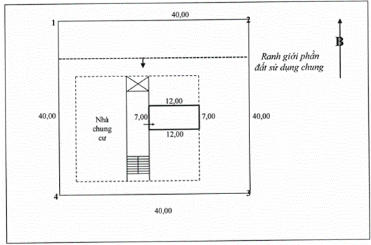
- Planning boundaries are displayed with continuous dotted lines and arrows indicating the planning range; safety corridor boundaries are displayed with alternating three-dot lines and dashed lines and arrows indicating the safety corridor range. Planning markers and safety corridor markers are represented by bold dots. Notes on the names of planning boundary lines and safety corridor lines should be placed appropriately on the diagram (Figure 1).
- Coordinates table displayed in the land plot diagram in accordance with Figure 5.
Figure 1. land plot diagram with land use limitations
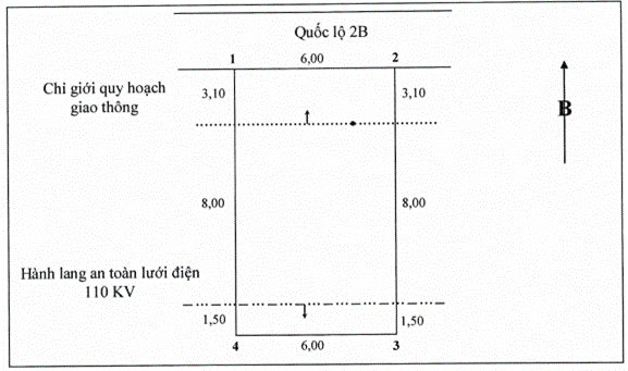
Figure 2. land plot diagram with multiple parcel edges
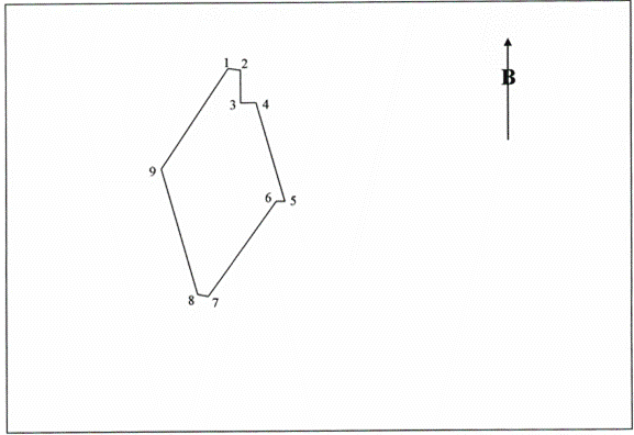
Figure 3. land plot diagram with curved edge
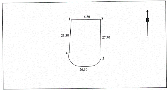
Figure 4. land plot diagram with length significantly larger than width showing ratio difference between length and width
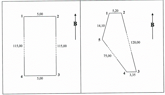
Figure 5. Coordinate table displayed in the land plot diagram:
| Parcel Peak Number | Coordinate | |
| X | Y | |
| 1 | 2287066.72 | 579119.17 |
| 2 | 2287063.35 | 579122.86 |
| 3 | 2287048.60 | 579109.34 |
| 4 | 2287051.98 | 579105.65 |
| 1 | ||
Figure 5a. Coordinate table and edge lengths displayed in the land plot diagram:
| Parcel Peak Number | Coordinate | Length (m) | |
| X | Y | ||
| 1 | 2287066.72 | 579119.17 | 20.00 |
| 2 | 2287063.35 | 579122.86 | 5.00 |
| 3 | 2287048.60 | 579109.34 | 20.00 |
| 4 | 2287051.98 | 579105.65 | 5.00 |
| 1 | |||
* Diagram of property affixed to land displayed on the Certificate
- The diagram of property affixed to land is represented by continuous dashed lines on the land plot diagram at the corresponding actual location.
If the boundary of the asset coincides with the parcel boundary, the parcel boundary is prioritized (Figure 6 and Figure 7);
- The diagram of houses and construction works (except apartments) shows the land occupation scope of the house and construction works (the area at the ground contact edge of the outer wall) of the house and construction works as follows:
+ For houses and other types of buildings, the house diagram shows the location, shape, and construction floor dimensions of the 1st floor (ground floor) at the ground contact point as per the outer wall of the house: no detailed interior layout is shown (Figure 6 and Figure 7). If houses share walls or rely on walls, the diagram is shown along the parcel boundary; with single-arrow indicators for relied walls or double-arrow indicators for shared walls (Figure 6);
+ For other construction works, the diagram shows the location, shape, and area at the ground contact edge of the construction;
- The apartment diagram shows the layout of the apartment floor (including the floor shape, staircase position, corridors); the location, shape, and area of the apartment are shown with solid, bold lines (without detailed interior floor plans), entrance door arrow symbols, and side lengths of the apartment (Figure 8);
- Boundary and parcel information displayed as per point 1 of this Guidance.
Side lengths of boundaries of property affixed to land shown in meters (m), rounded to two (02) decimal places.
Type of asset attached to the land (house, workshop, office, store, ...) noted in the diagram's middle area, consistent with land use map symbols.
Figure 6. land plot diagram with single and shared wall detached houses
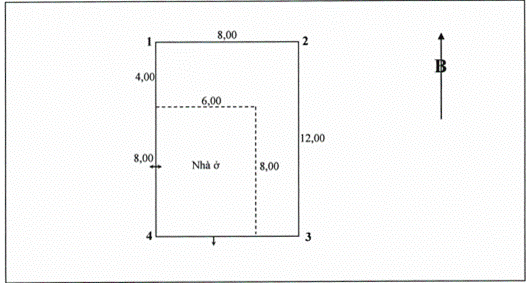
Figure 7. land plot diagram with construction works
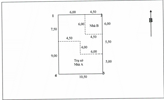
Figure 8. land plot diagram with apartment
* House and construction work diagram in the application dossier for Certificate issuance
- The house and construction work diagram in the application for Certificate issuance is displayed as per the instructions at points 1 and 2 of this Appendix.
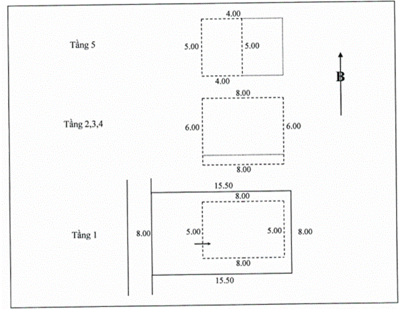
- For houses and buildings with multiple floors where the floor areas are not identical, they are shown as per points 1 and 2 of this Appendix and the supplementary instructions (Figure 9) as follows:
+ Show the layout of the 1st floor on the land plot diagram at the actual location;
+ Show the layout of floors with different shapes and areas compared to the 1st floor using dashed lines and the 1st-floor layout with dotted lines;
+ If multiple floors have identical shapes and areas, they should be presented in a single diagram and note the floor numbers.
Figure 9. Diagram of a 5-story house with different areas for the 1st floor and other floors; top 5th floor different from lower floors
More details can be found in Circular 10/2024/TT-BTNMT which comes into force in Vietnam from August 1, 2024.
- Group of Statistical Indicators on Road Traffic Vehicles from August 15, 2024
- Procedure for Reissuing the Certificate of Registration for Partnerships Due to Loss, Fire, Tear, Damage, or Destruction from August 13, 2024
- Strengthening the Assurance of Food Safety for the Mid-Autumn Festival in 2024
- District-level procedures for land statistics in Vietnam
- Vietnam: Hanoi to strive to improve the innovation index
- Groups of statistical indicators on road traffic infrastructure in developing traffic accident database in Vietnam
-
- Land for construction of public works in Vietnam ...
- 15:19, 15/08/2024
-
- District-level procedures for land statistics ...
- 13:00, 15/08/2024
-

- Vietnam: Hanoi to strive to improve the innovation ...
- 12:30, 15/08/2024
-

- Groups of statistical indicators on road traffic ...
- 11:30, 15/08/2024
-

- Regulations on cases considered as severe traffic ...
- 11:00, 15/08/2024
-

- Group of Statistical Indicators on Road Traffic ...
- 16:00, 15/08/2024
-

- Procedure for Reissuing the Certificate of Registration ...
- 15:55, 15/08/2024
-
- Land for construction of public works in Vietnam ...
- 15:19, 15/08/2024
-

- Strengthening the Assurance of Food Safety for ...
- 15:00, 15/08/2024
-

- District-level procedures for land statistics ...
- 13:00, 15/08/2024
