What are the guidelines for the free download of Atlas of Vietnam under the new general education program in the pdf file? What is the grade from which students will learn to use Atlas of Vietnam?
What are the guidelines for the free download of Atlas of Vietnam under the new general education program in the pdf file?
Atlas of Vietnam is a collection of maps and geographical information about Vietnam, providing data about its location, topography, population, economy, natural resources, and other natural factors of the country.
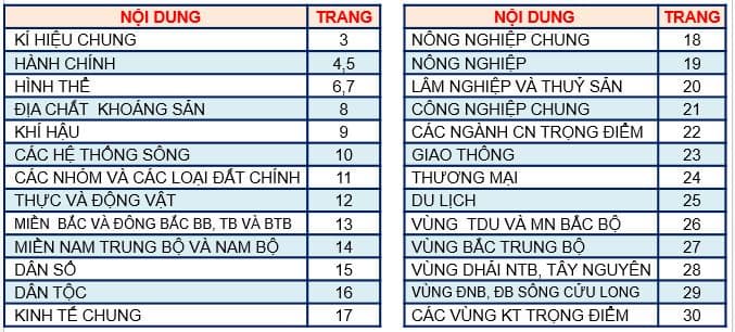
Table of Contents of Atlas of Vietnam in the pdf file:
Download Atlas of Vietnam pdf for free here

What are the guidelines for the free download of Atlas of Vietnam under the new general education program in the pdf file? What is the grade from which students will learn to use Atlas of Vietnam? (Image from Internet)
What is the grade from which students will learn to use Atlas of Vietnam?
Under the general education program of History and Geography at the lower secondary level issued with Circular 32/2018/TT-BGDDT, there are regulations on forming and developing geographical competencies as follows:
To form and develop geographical competencies for students, teachers choose representative practical knowledge, effectively use visual aids such as models, maps, video clips, etc. to form geographical symbols;... guide students from basic to advanced learning about relationships and causal connections in nature, in society, and the relationships between society, humans, and the environment.
To form and develop geographical competencies for students, teachers guide students to engage in the process of searching, arranging, and analyzing information by exploiting knowledge from map sources, charts, diagrams, images, data,... combined with field observations; emphasize the development of spatial thinking with questions like "What?", "Where?", "How?", "Spatial patterns?", "Characteristics of a locality, a nation?"; stimulate and nurture the curiosity and exploratory spirit of students towards nature and social life, a positive attitude towards sustainable development; practice the ability and habit of relating to local, national reality to develop geographical thinking;...
One of the most important measures for learning geography is developing skills in using learning tools such as maps, atlases, charts, statistical tables, some phone applications like compass, maps, GPS systems, thermometers, hygrometers, barometers, etc., photos, DVDs to search for multi-modal documents, e-books, ...
The forms of organizing teaching should also be diversified: combining individual learning, group learning, learning in class, in the field, project-based learning,...
Additionally, the general education program of History and Geography at the lower secondary level issued with Circular 32/2018/TT-BGDDT also stipulates the time allocated for History and Geography at the lower secondary level as follows:
| Content circuit | Grade 6 | Grade 7 | Grade 8 | Grade 9 | Entire Level |
| Geography | 45 | 42 | 41 | 40 | 42 |
| General Physical Geography | 45 | 11 | |||
| Geography of Continents | 42 | 11 | |||
| Physical Geography of Vietnam | 41 | 10 | |||
| Economic - Social Geography of Vietnam | 40 | 10 | |||
| History | 45 | 42 | 41 | 40 | 42 |
| World | 22 | 20 | 20 | 19 | 20 |
| Vietnam | 23 | 22 | 21 | 21 | 22 |
| Common Themes | 6 | 8 | 10 | 6 | |
| Periodic Evaluations | 10 | 10 | 10 | 10 | 10 |
Thus, lower secondary school students must know how to use learning tools such as maps, atlases, tables, and charts in History and Geography. 8th-grade students will learn about the Physical Geography of Vietnam in the Geography curriculum.
Therefore, students will learn to use the Atlas of Vietnam from 8th grade.
What is the Geography competency assessment table for lower secondary school students in Vietnam?
In the general education program issued with Circular 32/2018/TT-BGDDT, the Geography competency assessment table for lower secondary school students in Vietnam is specified as follows:
| Competency Component | Detailed Description |
| GEOGRAPHICAL SCIENTIFIC KNOWLEDGE | Understanding the world from a spatial perspective - Spatial orientation: knowing how to use various tools, especially maps, to accurately determine directions; knowing how to determine the geographical location of a place and directions on a map; knowing how to analyze the scope and scale of a territory. - Analysis of geographical position: knowing how to analyze the influence of geographical position on natural and socio-economic processes. - Analysis of distribution: describing the distribution characteristics of geographical objects and phenomena. - Expressing spatial understanding: being able to use mental maps to describe spatial understanding; being able to use diagrams to describe the spatial relationships between geographical phenomena and objects; describing a locality with distinctive natural, population, and economic characteristics. Hence, forming the notion of the identity of a locality, distinguishing one locality from another. Explaining geographical phenomena and processes (natural, socio-economic) - Analyzing interrelationships and causal relationships in nature + Describing some geographical phenomena and processes on Earth; describing the differentiation of nature across continents; describing the main characteristics of Vietnam's nature; explaining some factors affecting the differentiation of Vietnam's nature. + Using diagrams to describe the interaction between natural phenomena and processes. + Recognizing and analyzing causal relationships in the interactions between natural components in certain situations. - Analyzing interrelationships and causal relationships in socio-economics + Describing the spatial differentiation of population, settlements, economy, and culture phenomena; explaining some factors influencing that differentiation through a specific example. + Finding evidence of the reciprocal and causal relationships in the development, distribution of the population, and economic sectors. + Using diagrams to describe the interaction between socio-economic phenomena and processes. + Recognizing and applying some situations to analyze causal relationships in socio-economic life. - Analyzing the impact of natural conditions and resources on population distribution and production + Analyzing the impact of natural conditions and natural resources on the choice of natural exploitation methods by the population of continents. + Evaluating the impact of natural conditions and resource bases on population distribution, economic sector development, and economic structure formation through specific examples of Vietnam's geography. - Analyzing human societal impacts on the natural environment + Analyzing the ways humans in continents, in different regions of our country have exploited, used, and protected nature. |
| GEOGRAPHICAL EXPLORATION | Using geographical tools - Exploiting document texts: finding geographical content in a paragraph; being able to give titles, captions for pictures, drawings from a geographical perspective; knowing how to search for geographical documents for a local geography project or a theme about Vietnam's geography. - Using maps: stating the map elements; knowing how to read small-scale maps regarding physical geography, population geography, economic geography to extract necessary information and knowledge; knowing how to use map scales to determine the actual distance between two locations; knowing how to read cross-sections of topography. - Calculations, statistics: naming some measurable variables of natural phenomena and processes; applying some indicators of population growth, population distribution, and some indicators measuring economic development and economic structure. - Analyzing charts, diagrams: knowing how to read climate charts (temperature, precipitation); knowing how to read common types of charts in analyzing dynamics, structure, scale, and distribution characteristics of geographical phenomena and objects; understanding simple diagrams and models. Organizing fieldwork learning Knowing how to prepare necessary conditions before conducting field surveys; knowing how to use some simple and common tools for observation and field measurement; knowing how to write field journals; knowing how to write a report after a day of fieldwork. Exploiting the Internet for learning Knowing how to obtain information about natural, socio-economic subjects from teacher-recommended websites; knowing how to determine keywords in information search by theme; knowing how to evaluate accessed information; being able to download media materials and store them as files for an assigned project. |
| APPLYING LEARNED KNOWLEDGE AND SKILLS | Updating information, relating to reality Knowing how to search for information from reliable sources to update knowledge, statistics, etc., about studied localities, nations, world and domestic development trends; knowing how to relate to reality for a more in-depth understanding of geographical knowledge. Conducting practical exploration Having the ability to form and develop ideas about a practical exploration learning theme; having the ability to present the results of a personal or group project. |


- What are the 10 best sample argumentative essays on gratitude? What are the regulations on the attire of 7th-grade students in Vietnam?
- What are the 04 best sample analysis essays on the story "Lặng lẽ Sa Pa"? What are the general objectives of the Literature curricula in Vietnam?
- What are the 03+ sample outlines for expressive essays on people or events for 7th-grade students in Vietnam? What are the duties and powers of lower secondary schools in Vietnam?
- What is the sample outline for an analysis essay on Kim Lan's short story "Làng"? How many periodic assessments per semester do 9th-grade students in Vietnam undergo?
- What are the regulations on the method of enrollment for lower secondary education in Vietnam?
- What are the 03 sample essays on a form of art? What are the objectives of the Vietnamese language subject at the primary level?
- Is Decision No. 448/QD-BGDDT 2025 regarding the establishment of an inspection delegation for compliance with Circular 29 on extra classes in Vietnam available?
- What is the list of universities applying admission by academic records in Ho Chi Minh City in 2025? What are the priority policies in enrollment for undergraduate programs in 2025?
- What is the enrollment plan for 6th grade and 10th grade for the 2025-2026 school year in Quang Nam Province?
- Does the People's Police Academy of Vietnam announce the enrollment of 530 candidates in 2025?