Contents of work on river basin water level monitoring using remote sensing technology in Vietnam
What are the contents of work on river basin water level monitoring using remote sensing technology in Vietnam? - Thanh Tuan (Binh Phuoc)
 Article table of contents
Contents of work on river basin water level monitoring using remote sensing technology in Vietnam (Internet image)
On October 30, 2023, the Minister of Natural Resources and Environment issued Circular 16/2023/TT-BTNMT regulating techniques for monitoring water levels in river basins using remote sensing technology in Vietnam.
Contents of work on river basin water level monitoring using remote sensing technology in Vietnam
(1) Collect and enter data
- Satellite altimeter data is collected at global data storage, processing, and supply centers.
- The product type of I/GDR data used in river basin water level monitoring is selected to suit applications in continental hydrological research.
- Remote sensing data collected has an acquisition time compatible with the acquisition time of satellite altimeter data and is corrected for influence due to the Earth's curvature, receiver errors, and atmospheric interference. It is referenced to the WGS-84 Global Coordinate System and Reference System, Geographic projection, and point position errors are corrected using physical models, image control points, and digital elevation models.
- Documents related to the natural characteristics, hydro-climate, and operating regime of water reservoirs in the river basin (if any).
- Satellite altimetry data is collected in a compatible way with the reading and data processing software of popular altimeter satellites and stored in NetCDF format.
(2) Determine the coordinates of the satellite altitude measurement
- Information about the coordinates of satellite altitude measurements is obtained from high-frequency latitude and longitude data fields in data records; Measured values within the research scope are processed to reduce calculation time and volume.
- Coordinates of high-frequency satellite elevation measurements are exported as a data file in ASCII format to facilitate data display in a graphical environment.
(3) Determine the exact geographical coordinates of the virtual station
- The virtual station location is limited by a rectangular window with coordinates determined by the longitude and latitude of the upper left corner and lower right corner, displayed as a decimal number, to ensure all measurements on the water surface at the intersection are contained and limit measurements on the land surface. The virtual station position is calculated from the average longitude and latitude of all satellite elevations located above the water surface.
- Determining the window of satellite altitude measurements is done simultaneously with displaying measurement points along the satellite orbital track in all data cycles on the remote sensing data base, which have been referenced to the WGS-84 Global Coordinate System and Reference System. This is carried out at locations where the width of the river in the direction of the satellite orbit has a minimum size of 500 m for data from the traditional generation of radar altimeter satellites with low spatial resolution and 100 m for data from the generation of altimeter satellites applying synthetic aperture radar technology with high spatial resolution.
- The parameters of the satellite altimeter window that must be collected include: River/Lake, Hydrological station, Satellite, Satellite orbit, Virtual measuring station (Code, Longitude, Latitude), River/lake width, Distance to hydrological station/Dam (if any), shown according to the form in the Appendix attached to this Circular, data file format is *.docx (Microsoft Word Document).
(4) Calculate water level height
The water level height is determined by the difference between the satellite orbit altitude (Alt) and the satellite altimeter distance measurement value R and various correction numbers (including: time delay when radar signal pulses pass through the atmospheric environment and the influence of Earth's tides). Apply the formula below:
WSH = Alt - R + [DTC + WTC + IC + Ts ] - GC
In there:
- DTC is the refractive correction number in the dry troposphere
- WTC is the refraction correction number in the wet troposphere
- IC is the ionospheric refraction correction number
- Ts is the correction number due to the tidal influence of the solid Earth
- GC is the Geo-oir correction number
The atmospheric refraction correction number used is the standard model correction number found in the I/GDR data record. The water level elevation after calculation will be referenced to the EGM 2008 global geo-atmosphere.
(5) Export data to ASCII format
The results of calculating the water level height of the river basin are exported as a data file in ASCII format, in decimal form, with up to 4 numbers after the comma.
(6) Extract measurement values according to water surface objects
- Extraction of measurement values according to water surface objects at the intersection positions of the satellite orbital track with the river surface is performed on the basis of satellite data and vectorized with a polygon as the boundary. At that time, satellite measurements located at the limits of the polygon are used to calculate the water level elevation in the river basin.
- For rivers with medium and small widths (≤ 500 m), the river bank can be expanded to create a buffer zone that satisfies the conditions so that for each passing satellite orbit, at least 2–3 points in the polygon can be obtained to calculate the average water level height.
(7) Calculate the average water level with accuracy.
- The water level at each monitoring location in the river basin of each repeating period is calculated as an average from high-frequency satellite elevation measurements along the satellite orbit track obtained after extracting the measurement values according to the water surface object. The formula below is applied and shown according to the form in the Appendix attached to Circular 16/2023/TT-BTNMT.
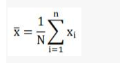
In there:
+ x̅ is the average value of water level height
+ xi is the water level height value of each high-frequency measurement within the polygon boundary of a virtual station
- N is the number of high-frequency measurement values within the polygon boundary of a virtual station
- The accuracy of the water level elevation measurement at each monitoring location in the river basin with each repeating cycle of the altimeter satellite is determined by the standard deviation error.
is applied according to the formula below:
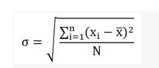
- For each repeating cycle, the standard deviation error of the water level elevation measurement must satisfy the condition ≤ 0.5 m, and the limit error of the water level elevation measurement must not exceed 1.0 m. In cases of complex terrain such as high mountains, steep slopes, or other unfavorable conditions for satellite measurements, the standard deviation error of the water level elevation measurement must not exceed 1.0 m, and the limit error of the water level elevation measurement must not exceed 2.0 m.
(8) Monitor water level changes in river basins
- Monitoring the water level in the river basin at each virtual station location is performed by monitoring the series of water level changes over time corresponding to the repeating cycles of the type of altimeter satellite used.
- The series of water level changes over time is established when the water level height at each repeating cycle is calculated and converted to the relative water level height compared to the water level height of any repeating period, chosen as the reference base, or compared to the average water level height during the entire monitoring period.
- At each location, virtual stations are implemented if the efficiency of the satellite altimeter (i.e., the ratio of the number of cycles for usable data to the total number of monitoring repetition cycles) reaches at least 30% or more.
- The series of water level changes over time at each virtual station location needs to show the rules of seasonal changes during the year.
- Assessing the reliability of water level monitoring results in the river basin is done on the basis of cross-validation by comparing two series of water level changes over time of two virtual stations close to each other with the assumption that the water level changes of these two virtual stations are similar. The correlation level of two series of water level changes is determined by the correlation coefficient R2.
(9) River basin water level monitoring products
- Satellite altimeter data is recorded on digital storage devices.
- Remote sensing image data is used in monitoring river basin water levels recorded on digital storage devices.
- Report on the results of calculating the water level height of the river basin at virtual stations must be recorded on digital storage devices.
- Report on the results of calculating the series of water level changes over time at virtual stations must be recorded on digital storage devices.
- River basin water level monitoring reports must be recorded on digital storage devices.
(10) Inspect, accept, and deliver products
- Technical inspection and product acceptance include the following stages:
+ Inspection and acceptance at the construction unit level;
+ Inspection and acceptance at the investor level;
+ Appraisal and acceptance of product quality and volume documents.
- Products are delivered after technical inspection, quality assessment, and acceptance at the investor level.
Legal basis: Article 5 of Circular 16/2023/TT-BTNMT
More details can be found in Circular 16/2023/TT-BTNMT taking effect on December 15, 2023.
Ho Quoc Tuan
- Key word:
- remote sensing technology
- in Vietnam
- Position and Duties of Defense Industry, Security Industry, and Industrial Mobilization
- Measures to Control Inflation in the Last 6 Months of 2024 in Hanoi
- Cases of revocation of certificate of vehicle and license plate registration for motorized vehicles and heavy-duty vehicles in road traffic in Vietnam from January 1, 2025
- 08 Rights of Social insurance beneficiaries in Vietnam from July 1, 2025
- Ministry of Health's response to the petition regarding overload condition at central-level hospitals in Vietnam
- Regulations on Study Time for Primary School Students in Ho Chi Minh City for the 2024-2025 School Year
-

- Cases of registration of security interests in ...
- 13:00, 01/09/2024
-
- 08 Rights of Social insurance beneficiaries in ...
- 12:00, 01/09/2024
-

- Development of human resources to advise on law ...
- 11:30, 31/08/2024
-

- National marine spatial planning in Vietnam for ...
- 09:29, 31/08/2024
-

- Newest guidelines for issuance of Certificate ...
- 18:00, 30/08/2024
-

- Position and Duties of Defense Industry, Security ...
- 17:00, 01/09/2024
-

- Measures to Control Inflation in the Last 6 Months ...
- 16:00, 01/09/2024
-

- Newest regulation on procedures for the issuance ...
- 15:00, 01/09/2024
-

- Cases of revocation of certificate of vehicle ...
- 14:00, 01/09/2024
-

- Cases of registration of security interests in ...
- 13:00, 01/09/2024
