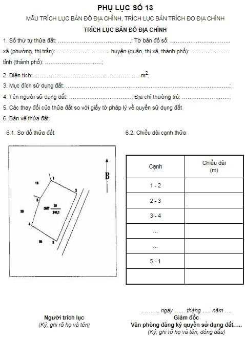
Sample extract of cadastral map, extract of the original of cadastral measurement 2022? What content should be shown on the cadastral map in Vietnam?
What is a topographic map? How many types of cadastral map on Vietnam are there?
Pursuant to Clause 4, Article 3 of the Land Law 2013 stipulates as follows:
Explanation of words
...
4. Cadastral map is a map showing land plots and related geographical factors, made according to the administrative unit of commune, ward or township, certified by a competent state agency.
Pursuant to Clause 1, Article 5 of Circular 25/2014/TT-BTNMT stipulates as follows:
Mathematical foundations
1. Cadastral maps are made at the scales 1:200, 1:500, 1:1000, 1:2000, 1:5000 and 1:10000; on the projection plane, in the projection zone of 3 degrees, the axis meridians according to each province and city directly under the Central Government, the national reference system and coordinate system VN-2000 and the current national elevation system.
Axis meridians for each province and centrally run city are specified in Appendix 02 to this Circular.
Thus, a cadastral map in Vietnam is a type of map showing land parcels and related geographical factors at the commune, ward and township level and is determined by a competent authority.
Currently, cadastral maps have scale types of 1:200, 1:500, 1:1000, 1:2000, 1:5000 and 1:10000.

Sample extract of cadastral map in Vietnam, extract of the original of cadastral measurement 2022? What content should be shown on the cadastral map in Vietnam? (Image from the internet)
What does the topographic map show?
Pursuant to Clause 1, Article 8 of Circular 25/2014/TT-BTNMT stipulates as follows:
Contents of cadastral map
1. The main content elements shown on the cadastral map include:
1.1. Map frame;
1.2. Coordinate control points, national elevations of all grades, cadastral points, external image control points, measurement control points with stable landmarks;
1.3. Administrative boundary landmarks, administrative boundary lines at all levels;
1.4. The planning boundary; boundaries of traffic safety protection corridors, irrigation, dikes, electrical conduction systems and other public works with safety protection corridors;
1.5. The boundary of the land plot, the type of land, the ordinal number of the land plot, the area of the land plot;
1.6. Houses and other construction works: only show on the map the main construction works suitable for the use purposes of the land plot, except for temporary construction works. Underground works, when required to be shown on the cadastral map, must be specified in the technical design - work cost estimate;
1.7. Objects occupying land that do not form land parcels such as roads, irrigation works, dikes, rivers, streams, canals, canals and other land occupation elements along lines;
1.8. Features and works of historical, cultural and social value and high directional significance;
1.9. Ground shape or elevation note (when required, it must be specified in the technical design - work estimate);
1.10. Explanatory notes.
When noting elements of cadastral map content, they must comply with the regulations on cadastral map symbols specified in Section II and Point 12, Section III of Appendix 01 attached to this Circular.
Accordingly, the current cadastral map in Vietnam will show 10 main contents listed in accordance with the above regulations.
How accurate is the cadastral map in Vietnam?
Pursuant to Article 7 of Circular 25/2014/TT-BTNMT (amended by Clause 1, Article 8 of Circular 33/2017/TT-BTNMT) as follows:
Cadastral map accuracy
1. The square error of the position of the plane of the control point, the measuring station point compared to the starting point after the adjustment does not exceed 0.1 mm calculated according to the scale of the map to be made.
2. The error indicating the corner point of the map frame, the intersection of the km grid, the national coordinate points, the cadastral points, the points with other coordinates on the digital cadastral map is specified as zero ( no error).
3. For cadastral maps, in paper form, the error of the length of the edge of the map frame does not exceed 0.2 mm, the diagonal of the map does not exceed 0.3 mm, the distance between the coordinate point and the corner point of the frame the map (or the intersection of the km grid) does not exceed 0.2 mm from the theoretical value.
...
7. When checking the error, both the error of the point position must be checked simultaneously with the nearest control point and the mutual error of the point position. The absolute value of the maximum error when testing must not exceed the absolute value of the allowed error, the number of test errors is equal to or close to (from 90% to 100%) the absolute value of the maximum error. allow no more than 10% of the total number of test cases. In no case should the above errors be systematic.”
Thus, the error for the cadastral map is done according to the above regulations.
Extracts of cadastral maps, extracts of the original cadastral measurements will include what information?
Pursuant to Appendix 13 issued together with Circular 25/2014/TT-BTNMT stipulating the form of cadastral map extract, cadastral map in Vietnam extract.

Accordingly, the cadastral map in Vietnam table of contents sample will have the following information:
- Ordinal number of land plot, map sheet No
- Area of land plot
- Purpose of using land
- Name and permanent address of the land user
- Changes of the land plot compared to legal documents on land use rights
- Land plot drawing, including plot of land plot, length of side of plot
Download the sample cadastral map extract, extract the original cadastral measurement: here.
LawNet
