Vietnam: What are details of the updated information on storm no. 4 situation on September 19, 2024? What is the forecast for storm no. 4 in the next 24 hours?
Vietnam: What are details of the updated information on storm no. 4 situation on September 19, 2024? What is the forecast for storm no. 4 in the next 24 hours?
According to Clause 1, Article 11 of Decision 18/2021/QD-TTg:
Content of storm forecast and warning
1. Storm news title: correspondingly recorded according to names from Clauses 1 to 6, Article 9 of this Decision, attached with the serial number of the storm determined according to the order of storms active in the East Sea throughout the year; no numbers assigned to storms near the East Sea.
...
The identification of the storm's serial number is based on the order of storms active in the East Sea within a year and no serial numbers are assigned to storms near the East Sea.
Therefore, Storm No. 4 understood to be the fourth storm active in the East Sea within a year.
According to the National Center for Hydrometeorological Forecasting, the situation of Storm No. 4 on September 19, 2024, is as follows:
(1) Current Status of the Storm
At Con Co (Quang Tri), there have been strong winds at Level 6, gusts at Level 8; Hoanh Son (Ha Tinh) has strong winds at Level 6, gusts at Level 8; Dong Hoi (Quang Binh) has strong gusts at Level 7.
From last night until this morning in the North and Central Central region, there has been moderate to heavy rain, with some places experiencing very heavy rain: Hoa Bac (Da Nang) 152mm; Bach Ma (Thua Thien Hue) 270mm, Huong Phu (Thua Thien Hue) 249mm; Drakrong (Quang Tri) 112 mm...
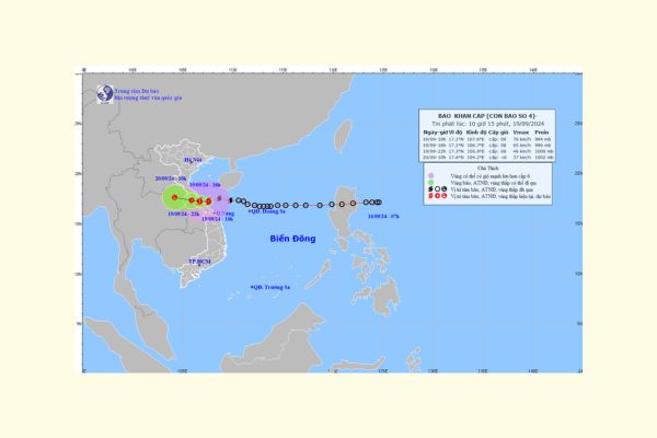
At 07:00 on September 19, the storm's center was located approximately at 17.5 degrees North Latitude; 108.7 degrees East Longitude, about 190km east of Quang Binh-Quang Tri. The maximum wind speed near the storm's center was strong at Level 8 (62-74km/h), gusts at Level 10; primarily moving westward at about 20km/h.
(2) Storm Forecast (in the next 24 hours)
(1) Current Status of the Storm
At Con Co (Quang Tri), there have been strong winds at Level 9, gusts at Level 10; Hoanh Son (Ha Tinh) has strong winds at Level 6, gusts at Level 8; Le Thuy (Quang Binh) has strong winds at Level 6, gusts at Level 8.
From last night until this morning (September 19) in the North and Central Central region, there has been moderate to heavy rain, with some places experiencing very heavy rain: Hoa Bac (Da Nang) 166mm; Bach Ma (Thua Thien Hue) 309mm, Huong Phu (Thua Thien Hue) 270mm, ...
At 10:00 on September 19, the center of Storm No. 4 (international name Soulik) was approximately at 17.2 degrees North Latitude; 107.6 degrees East Longitude, over the waters of Quang Binh-Thua Thien Hue. The maximum wind speed near the storm's center was strong at Level 8-9 (62-88km/h), gusts at Level 10-11 (89-117km/h); moving west-southwest at about 25km/h.
(2) Storm Forecast (in the next 24 hours)
| Forecast Time | Direction, Speed | Position | Intensity | Dangerous Area | Disaster Risk Level (Affected Areas) |
| 16:00/September 19 | West, about 20-25km/h | 17.2N-106.7E; on land in Quang Binh-Quang Tri provinces | Level 8, gusts at Level 10-11 | 15.5N-19.5N; west of longitude 110.0E | Level 3: coastal regions from Nghe An to Da Nang (including Con Co, Hon Ngu); coastal land areas from Ha Tinh to Thua Thien Hue |
| 22:00/September 19 | West, 20km/h | 17.3N-105.9E; on land in Central Laos | Level 6, gusts at Level 8 | 16.0N-19.5N; west of longitude 109.0E | Level 3: coastal regions from Nghe An to Da Nang (including Con Co Island, Hon Ngu); coastal land areas from Ha Tinh to Quang Tri |
| 10:00/September 20 | West-northwest, about 15-20km/h, weakening and dissipating | 17.6N-104.2E; in Central Laos | < Level 6 |
(3) Forecast Impact of the Storm
| Strong Winds, High Waves, Rising Water |
| On the Sea: - The sea from Nghe An to Da Nang (including Con Co Island, Hon Ngu) will have strong winds at Level 6-7 (39-61km/h), wave heights from 2.0-4.0m, areas near the storm center at Level 8-9 (62-88km/h), gusts at Level 10-11 (89-117km/h), wave heights from 3.0-5.0m, the sea is very rough. Additionally, due to the influence of the strong southwest monsoon, the sea area from Binh Dinh to Ca Mau, the southern part of the Central East Sea region, and the Southern East Sea region (including Truong Sa archipelago) will have strong southwest winds at Level 6, sometimes Level 7, gusts at Level 8-9, wave heights from 3.0-5.0m. The sea is very rough. The northern part of the Gulf of Tonkin has strong winds at Level 5, sometimes Level 6, gusts at Level 7-8. Wave heights from 2-3m. The sea is rough. Coastal areas from Ha Tinh to Thua Thien Hue need to be cautious of storm surges from 0.3-0.5m, combined with high tides and strong waves causing coastal embankment erosion, flooding in low-lying areas during the evening of September 19. Vessels operating in the aforementioned dangerous areas are at risk of experiencing thunderstorms, tornadoes, strong winds, large waves, high tides, and storm surges. On the Mainland: - Coastal land areas from Ha Tinh to Thua Thien Hue will experience strong winds at Level 6-7, areas near the storm center at Level 8, gusts at Level 10-11; deep inland areas will experience strong gusts at Level 6-7. - Be cautious of the appearance of strong thunderclouds ahead of the storm circulation. In the weather conditions of heavy thunderstorms, the accompanying consequence could be the fall of green trees, roofing sheets, and advertising boards being blown away. |
| Heavy Rain |
| - From September 19 to September 20, in the North Central region and Central Central region, there will be heavy to very heavy rain with common rainfall from 100-300mm, locally over 500mm. Be cautious of high-intensity rain (>150mm/6 hours) in the area from Quang Tri-Da Nang on September 19. - On September 19, the Central Highlands and Southern regions will have moderate to heavy rain and thunderstorms, locally with very heavy rain with common rainfall from 20-40mm, locally over 70mm. - Heavy rain leads to flooding in urban areas, densely populated areas due to slow drainage. |
Vietnam: What are details of the updated information on storm no. 4 situation on September 19, 2024? What is the forecast for storm no. 4 in the next 24 hours? (Image from the Internet)
Prime Minister of Vietnam's Directive on proactive response to the tropical depression that may develop into Tropical Storm No. 4
Based on Official Telegram 97/CD-TTg of 2024, the Prime Minister of Vietnam directs proactive response to the tropical depression that might intensify into Tropical Storm No. 4 as follows:
- The Minister of the Ministry of Natural Resources and Environment is instructed to direct the hydrometeorological forecasting agency to continue to closely monitor, forecast and promptly provide complete information about the tropical depression evolution to relevant agencies and the public to proactively implement response measures as regulated.
- The Ministers of relevant Ministries and the Chairpersons of the People's Committees of the above-mentioned provinces and cities, based on their assigned functions and tasks, are instructed to closely monitor, regularly and constantly update information on the evolution of tropical depression, storms, and floods to proactively direct and implement suitable response measures according to the disaster evolution that might impact their management scope, including:
+ Promptly deploy measures to ensure safety for ships, vessels, and activities at sea and along the coast.
+ Review and refine the response scenarios for tropical depression, storms, floods, landslides, flash floods, focusing on ensuring safety, minimizing property damage to the People, scientific and safe operation of hydropower and irrigation reservoirs.
+ Proactively arrange forces, materials, and vehicles, especially in the localities expected to be directly affected by storms and floods, to be ready to deploy rescue and relief operations when required.
- Vietnam Television, the Voice of Vietnam, and other media agencies to increase the broadcasting duration, provide timely information so that the public can grasp the tropical depression, storm, and flood evolution, the directives from competent agencies, and acquire skills to cope with natural disasters, especially landslides, flash floods, flooding to minimize damages.
- The Minister of Agriculture and Rural Development to organize 24/7 duty to closely monitor the situation, proactively direct and urge localities to deploy suitable response measures according to actual disaster evolution, promptly report and propose to the Prime Minister and Deputy Prime Minister to direct issues beyond their authority.
- The Office of the Government of Vietnam to monitor and urge Ministries and localities to strictly implement this Official Telegram; promptly report to the Prime Minister and the responsible Deputy Prime Minister about sudden and arising issues.
What are regulations on production of broadcasts on forecasts and warnings about storm no. 4?
Based on Article 9 of Decision 18/2021/QD-TTg, the storm forecast, and warning bulletin is issued including:
(1) News of the storm near the East Sea
Storm news near the East Sea is issued when a storm is active outside the East Sea and is likely to move into the East Sea within the next 48 hours.
(2) News of the storm on the East Sea
News of the storm on the East Sea is issued when a storm is active on the East Sea and has no possibility of directly affecting mainland Vietnam within the next 48 hours.
(3) Emergency storm news
Emergency storm news is issued when a storm is likely to directly affect mainland Vietnam within the next 48 hours.
(4) News of the storm on the mainland
News of the storm on the mainland is issued when one of the following conditions is met:
- The storm's center has entered mainland Vietnam and its strongest winds remain at Level 8 or above;
- The storm's center has entered neighboring countries, but its strongest winds remain at Level 8 or above and might directly affect Vietnam within the next 24 to 48 hours.
(5) Quick storm news
Quick storm news is issued when emergency storm news is released or in cases of complex storm evolution.
(6) Final storm news
Final storm news is issued when one of the following conditions is met:
- The storm has weakened into a low-pressure area;
- The storm has landed in neighboring countries or moved out of the territory, no longer directly affecting Vietnam;
- The storm has moved out of the East Sea and has no possibility of returning to the East Sea.
(7) Large waves, rising water due to storm news
News forecasting and warning of large waves and rising water due to storms shall be issued immediately upon the release of emergency storm news.
LawNet