Guidelines for data synchronization of cadastral dossiers at all levels in Vietnam

What are the guidelines for data synchronization of cadastral dossiers at all levels in Vietnam? - Khanh Duy (Can Tho)
 Article table of contents
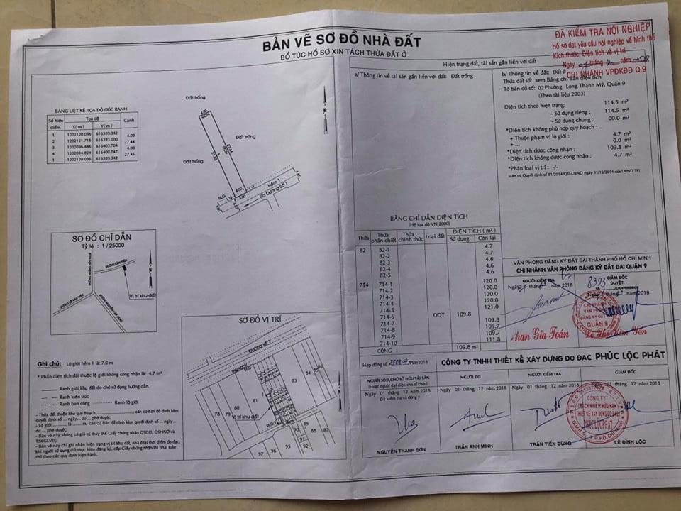
Guidelines for data synchronization of cadastral dossiers at all levels in Vietnam (Internet image)
Regarding this issue, LawNet would like to answer as follows:
1. Guidelines for data synchronization of cadastral dossiers at all levels in Vietnam
Guidelines for data synchronization of cadastral dossiers at all levels according to Article 27 of Circular 24/2014/TT-BTNMT are as follows:
- Places establishing digital cadastral dossier, data synchronization of cadastral dossiers at all levels shall be carried out along with the synchronization of cadastral database as prescribed by the Ministry of Natural Resources and Environment on establishment of land database.
After updating the received database synchronization, land registration offices must extract in digital cadastral dossier additional first-time registration data; updated change registration data from the cadastral database.
- Data synchronization of copies of communal cadastral dossiers shall comply with the following provisions:
+ For the commune-level administrative units using directly the digital cadastral dossiers via the transmission line connected to the cadastral database of the province and district, the commune-level cadastral officers do not synchronize the data.
For places which have established digital cadastral dossier, but communal administrative units have not developed the direct use of digital cadastral dossiers from database of the province and district, branch of land registration office or land use right registration Office at district level shall periodically extract, copy in the storage device of data newly updated and readjusted and send to cadastral officers at commune level to update the copies of digital cadastral dossiers forms of commune.
Periodical time for the extraction and sending data to commune shall be defined in accordance with conditions of each commune by the branch of land registration office or land use right registration office at district level, but it shall be no more than 15 days once.
Cadastral officers at commune level must enter the data newly updated and readjusted sent by brace of land registration office or land use right registration office into copies of digital cadastral dossiers of communes within 02 working days from date of receipt to manage and use;
+ For the commune-level administrative units which still use paper cadastral records, within 03 working days from the date of update and revision of the cadastral dossiers for settled changes, land registration authority must notify in writing the communal cadastral officials to update, readjust copies of cadastral dossiers.
After receiving notification on update, revision of cadastral dossier, cadastral officers at commune level shall update and revise into copies of cadastral dossiers under their management to use within 03 working days.
2. Regulations on inspection of preparation, readjustment of cadastral dossiers in Vietnam
Regulations on inspection of preparation, readjustment of cadastral dossiers according to Article 28 of Circular 24/2014/TT-BTNMT are as follows:
- Inspection of cadastral dossiers shall include:
+ Inspection after initial establishment before being put into use;
+ Inspection during update and readjustment of changes.
++ Inspection content of cadastral dossiers shall include:
++ Inspection of the presentation of cadastral dossiers;
+ Inspection of the consistency of information among documents, including:
++ The unification of information on numbers, area and land type between measurement documents to register and land-itemizing book;
++ The unification of information on use purpose as planning between land –itemizing book and land-use planning map ;
++ The unification of information on numbers, area and land type between cadastral book and land-itemizing book;
++ The unification of first-time registration information between cadastral dossiers and registration procedures of land , property on land and stored copy of Certificate or scan of Certificate stored in cadastral database ( if any);
++ The unification of change registration information between change registration application and cadastral dossiers , stored copy ( or scan) of Certificate, use measurement documents, land-itemizing book;
++ The unification of the readjustment of the boundaries, area of the land plot between the land change registration application and cadastral map (or other measurement documents used to register);
+ Inspection of the completeness of contents of each document shall include:
++ Inspection of numbers of land plot entered the land-itemizing book;
++ Inspection of the number of initial registration application, change registration application of land and property on land which have been updated, readjusted in cadastral book;
++ Inspection of the number of scans of Certificates and legal documents on land use rights, ownership of property on land stored in cadastral compared with the number of current documents of the same type ;
+ Inspection content of measurement and drawing cadastral maps, land-itemizing book shall comply with the provisions of the cadastral map of the Ministry of Natural Resources and Environment.
- Responsibilities and inspection level of cadastral dossiers shall be defined as follows:
+ the Service of Natural Resources and Environment shall inspect, accepted the quality of cadastral dossier compiled initially before being put into use except for cases specified in point c of this paragraph.
Inspection level shall comply with provisions of the Ministry of Natural Resources and Environment on inspection, verification and acceptance of cadastral work, products;
+ Land Registration Authority shall:
++ Inspect the measurement, readjustment and division of the land plot on the cadastral map; inspect the cadastral measurements of the land plot or other types of maps under paper and digital form for places have had no cadastral map before using to register, issue the Certificate for the cased under the competence;
++ Inspect regularly the update and readjustment of complied digital cadastral dossiers
Regularly inspect the update, readjustment of cadastral dossiers for all registered cases for places have not established digital cadastral dossiers;
+ Land registration office or land use right registration office at province level shall periodically inspect the update, readjustment of cadastral dossiers compiled by branch of land registration offices or land use right registration offices at district level. Inspection level shall be a minimum of 20% of the updated and readjusted cases;
+ branch of land registration offices or land use right registration offices at district level shall inspect at least once every 6 months the update and readjustment of the copies of cadastral dossiers compiled by cadastral officers at commune level.
- Key word:
- cadastral dossiers
- in Vietnam
- Cases of land rent exemption and reduction under the latest regulations in Vietnam
- Economic infrastructure and social infrastructure system in Thu Duc City, Ho Chi Minh City
- Regulations on ordination with foreign elements in religious organizations in Vietnam
- Increase land compensation prices in Vietnam from January 1, 2026
- Determination of land compensation levels for damage during land requisition process in Vietnam
- Who is permitted to purchase social housing according to latest regulations in Vietnam?
-
- Emergency response and search and rescue organizations ...
- 10:29, 11/09/2024
-

- Handling of the acceptance results of ministerial ...
- 09:30, 11/09/2024
-
- Guidance on unexploded ordnance investigation ...
- 18:30, 09/09/2024
-

- Sources of the National database on construction ...
- 16:37, 09/09/2024
-

- General regulations on the implementation of administrative ...
- 11:30, 09/09/2024
-

- Notable new policies of Vietnam effective as of ...
- 16:26, 11/04/2025
-
.Medium.png)
- Notable documents of Vietnam in the previous week ...
- 16:21, 11/04/2025
-
.Medium.png)
- Notable documents of Vietnam in the previous week ...
- 16:11, 02/04/2025
-
.Medium.png)
- Notable new policies of Vietnam to be effective ...
- 16:04, 02/04/2025
-
.Medium.png)
- Notable new policies of Vietnam effective from ...
- 14:51, 21/03/2025
