Content of the Scheme on Early Warning of Landslides and Flash Floods in Mountainous and Midland Areas of Vietnam
 (1).png)
What are the contents of the Scheme on Early Warning of Landslides and Flash Floods in Mountainous and Midland Areas of Vietnam? – Ngoc Trung (Lam Dong)
 Article table of contents

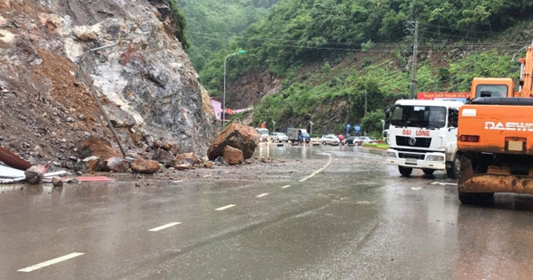
Content of the Scheme on Early Warning of Landslides and Flash Floods in Mountainous and Midland Areas of Vietnam (Internet image)
Regarding this issue, LawNet would like to answer as follows:
On October 27, 2023, the Prime Minister issued Decision 1262/QD-TTg approving the Scheme for Early Warning of Landslides and Flash Floods in Mountainous and Midland Areas of Vietnam.
Content of the Scheme on Early Warning of Landslides and Flash Floods in Mountainous and Midland Areas of Vietnam
The Scheme on Early Warning of Landslides and Flash Floods in Mountainous and Midland Areas of Vietnam has 05 specific contents, as follows:
(1) Review and develop a complete system of legal documents, processes, and technical regulations to serve the implementation of tasks related to zoning and early warning of natural disasters such as landslides and flash floods
- Complete legal documents, regulations, and technical procedures for forecasting and warning of flash floods and landslides; regulations and technical procedures for measuring, investigating, and surveying the current situation; creating risk zoning maps; and zoning risks due to flash floods and landslides guide localities to implement them.
- Complete economic-technical norms on detailed investigation and survey work, creating risk zoning maps, and zoning risks of landslides and flash floods at large scales.
- Complete documents on regulations on coordination, operation, exploitation, and updating of landslide and flash flood data systems; providing and sharing information between management - investigation and assessment agencies - authorities - local communities in early warning work on landslides and flash floods.
(2) Investigate, build data sets, create current status maps to serve hazard zoning maps and risk zoning due to landslides and flash floods
- Apply remote sensing technology to investigate, monitor, and update information on the current status of landslides, flash floods, and information layers for early warning; identify key areas at high risk of landslides and flash floods.
- Investigation, field survey, and collection of information on landslides and flash floods; information on infrastructure, people's livelihoods, and the economy; Information on geological - hydrometeorological characteristics to serve the calculation of vulnerability zoning maps and exposure levels due to landslides and flash floods is displayed on a scale of 1:50,000 based on geographical information at a scale of 1:25,000, 1:10,000, and larger (1:5,000, 1:2,000).
- Create maps of the current status of landslides and flash floods and maps of geological and hydrological components at a scale of 1:50,000 displayed on a geographic information platform at a scale of 1:25,000; scale 1:10,000 and larger (1:5,000, 1:2,000).
(3) Create hazard zoning maps and risk zoning due to landslides and medium- and large-scale flash floods
- Create hazard zoning maps and natural disaster risk zones due to landslides and flash floods at a scale of 1:50,000 displayed on a geographic information platform at a scale of 1:25,000 for 15 provinces: 03 provinces in the Northern region (Phu Tho, Vinh Phuc, Thai Nguyen), 05 provinces in the Central region (Binh Dinh, Phu Yen, Khanh Hoa, Ninh Thuan, Binh Thuan), 05 provinces in the Central Highlands region (Kon Tum, Gia Lai, Dak Lak, Dak Nong, Lam Dong), and 02 provinces in the Southeast region (Binh Phuoc, Dong Nai).
- Create hazard zoning maps and natural disaster risk zones due to landslides and flash floods at a scale of 1:10,000 and larger for about 1,500 high-risk areas with landslides and flash floods.
(4) Establish and maintain the operation of the information system - early warning of landslides and flash floods
- Establish an information and early warning system: upgrade and develop landslide and flash flood warning models for 37 midland and mountainous provinces of Vietnam; Build an information system - early warning of landslides and flash floods in real time, with coordination between management agencies, warning and forecasting agencies, and people in acquiring, analyzing, and processing data information; Update the database on landslides, flash floods, socio-economics, and damage situations for information and an early warning system; Trial operation at the central government and in 37 midland and mountainous provinces of Vietnam.
- Maintain the operation of the information and early warning system: invest in equipment and information technology infrastructure to serve the operation of the early warning system; develop regulations for operating, exploiting, and updating the shared database system; Apply remote sensing technology to monitor and update the database to serve early warnings of landslides and flash floods for the information and early warning system.
(5) Strengthen research, application of science and technology, and international cooperation in early warning of landslides and flash floods; improve community capacity in communication and use of early warning information
- Research and apply modern technology in forecasting, warning, and building an information system - early warning of landslides and flash floods.
- Improve communication capacity, use early warning information to prevent and avoid landslides and flash floods in the community, and reduce damage caused by landslides and flash floods.
- Strengthen international cooperation in research, sharing methods, data information, and experience in early warning of landslides, flash floods, hazard zoning, and risk zoning; at the same time, take advantage of the technical and financial support of countries and international organizations for early warning of landslides and flash floods.
More details can be found in Decision 1262/QD-TTg, taking effect from the date of signing.
- Key word:
- landslides
- in Vietnam
- Number of deputy directors of departments in Vietnam in accordance with Decree 45/2025/ND-CP
- Cases ineligible for pardon in Vietnam in 2025
- Decree 50/2025 amending Decree 151/2017 on the management of public assets in Vietnam
- Circular 07/2025 amending Circular 02/2022 on the Law on Environmental Protection in Vietnam
- Adjustment to the organizational structure of the Ministry of Health of Vietnam: Certain agencies are no longer listed in the organizational structure
- Vietnam aims to welcome 22-23 million international tourists in Vietnam in 2025
-
- Contents of the estimated norms for digging and ...
- 08:00, 30/01/2025
-
- Emergency response and search and rescue organizations ...
- 10:29, 11/09/2024
-

- Handling of the acceptance results of ministerial ...
- 09:30, 11/09/2024
-
- Guidance on unexploded ordnance investigation ...
- 18:30, 09/09/2024
-

- Sources of the National database on construction ...
- 16:37, 09/09/2024
-

- Notable new policies of Vietnam effective as of ...
- 16:26, 11/04/2025
-
.Medium.png)
- Notable documents of Vietnam in the previous week ...
- 16:21, 11/04/2025
-
.Medium.png)
- Notable documents of Vietnam in the previous week ...
- 16:11, 02/04/2025
-
.Medium.png)
- Notable new policies of Vietnam to be effective ...
- 16:04, 02/04/2025
-
.Medium.png)
- Notable new policies of Vietnam effective from ...
- 14:51, 21/03/2025
