Approval of the Phu Quoc City General Planning project until 2040 in Vietnam

Has the Phu Quoc City General Planning project until 2040 in Vietnam been approved by the Prime Minister?
 Article table of contents
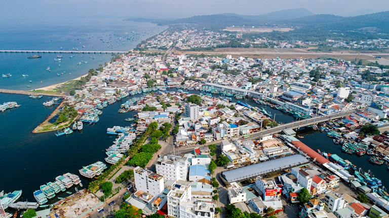
Approval of the Phu Quoc City General Planning project until 2040 in Vietnam (Internet image)
Approval of the Phu Quoc City General Planning project until 2040 in Vietnam
The Prime Minister issued Decision 150/QD-TTg in 2024, approving the General Planning project of Phu Quoc City, Kien Giang Province, until 2040.
**Goal of preparing Phu Quoc City General Planning
- The development orientation of Phu Quoc City until 2040, in line with the requirements of development until 2030 and the Kiengiang Province Plan for the period of 2021–2030, and the vision until 2050, approved by the Prime Minister in Decision 1289/QD-TTg in 2023, aim to achieve comprehensive, balanced, and sustainable development, harmonizing economic development with environmental protection, preservation of historical and cultural heritage, and ensuring security and defense. It will inherit approved plans that are suitable for practical conditions and comply with legal regulations and ensure the ability to meet development needs in the event of the formation of special administrative-economic units and the separation of the Tho Chau (Tho Chu) island commune into a separate district.
- Develop Phu Quoc City into an island city; High-quality tourism and resort service centers with identity and appeal to domestic and international tourists; commercial and service centers; health care and nursing centers applying high technology of regional and international stature; political - cultural centers; Quality and cohesive living space for people on the island; Urban development is geared towards green, smart growth, energy savings, and adaptation to climate change, creating resources for development investment.
- Serve as a legal basis for management, investment attraction, and implementation: planning and implementing urban development planning and programs, making zoning plans and detailed plans, and making investment projects to build the technical infrastructure of Phu Quoc city.
Urban development forecasts
**Population size:
- By 2030, the entire urban population is forecast to be about 400,000 people, including an official population of about 255,000 people and other population segments such as tourists, workers,...
- By 2040, the entire urban population is forecast to be about 680,000 people, including an official population of about 430,000 people and other population segments such as tourists, workers,...
**Land size:
- By 2030: urban construction land will be about 9,950 hectares (including 5,590 hectares of existing status and 4,360 hectares of new construction); of which: civil land is about 3,032 hectares (the target is about 77 m2/person), and non-civil land is about 6,918 hectares.
- By 2040: urban construction land will be about 14,785 hectares, of which: civil land is about 6,042 hectares (target of about 89 m2/person), and non-civil land is about 8,743 hectares.
Orientation for spatial development
**Urban development structure model
Phu Quoc City develops according to a multi-center model, forming a concentrated urban chain including:
- The main urban - tourism center in the existing ward area (Duong Dong, An Thoi) and new centers in Cua Can and Bai Truong.
- Urban - tourism chain with low density along the main axis North - South An Thoi
- White Bridge, traffic axis around the island of Bai Vong - Bai Thom - Rach Tram
- Rach Vem - Ganh Dau - Cua Can - Duong Dong - Bai Truong - Bai Khem connecting An Thoi seaport, Bai Dat Do, and Phu Quoc international airport.
- Natural framework includes national parks, protective forests, urban parks, theme parks, and open spaces that are protected and natural ecosystems restored, creating attractive natural landscapes for residents and visitors to experience.
**Development zoning
Phu Quoc city space is divided into 13 development areas, specifically as follows:
- Division 1 (Duong Dong area)
+ Belonging to Duong Dong ward and is part of Cua Duong and Duong To communes, with the following scope and boundaries: to the north, it borders Ong Lang mountain and Khu Tuong mountain (Cua Duong commune); to the south, it borders the airport (Duong To commune); to the east, it borders the national forest and Suoi Da mountain; and to the west, it borders the sea. The scale is about 6,192 hectares.
+ Characteristics: It is an administrative, political, cultural, sports center; financial center, urban tourism and commercial center, and the main mixed urban - tourism area of Phu Quoc city.
+ Development orientation:
. Developing a new and modern mixed-function urban - tourism, commercial, and financial area in the old airport area and coastal area. Renovate and form a strip of public space and central street along the Duong Dong River. Organize urban space with the central water surface landscape, retain the river structure associated with greenery and riverside urban landscape, and add water surfaces, parks, and public spaces for urban subdivisions connected to this main water surface system.
. Open urban structure with mixed-use functions, associated with coastal public parks.
. Renovate and upgrade on the basis of existing spatial structures and connect with new development areas. Urban development is associated with agricultural ecology in some areas.
- Division 2 (Bai Truong area)
+ Belonging to Duong To commune, with the following scope and boundaries: the North borders the airport; The South borders An Thoi ward; The East borders the Bay Dragon mountain range; The west borders the sea. The scale is about 2,485 hectares.
+ Characteristics: It is the main mixed urban - tourism functional area, commercial center, tourism services, entertainment, and public services.
+ Development orientation:
. Organize a strip of parks, coastal public squares, landscape axes, and public spaces connecting the coastal area and the Eastern mountain area.
. Organize water surface space on the basis of improving and exploiting low-lying terrain areas, promoting the existing system of low-lying areas and streams, creating a series of landscape lakes alternating in urban areas,
At the same time, it plays the role of regulating and supporting water drainage.
. Develop mixed-use urban tourism areas, resettlement areas, and sports centers.
. Develop, renovate, embellish, expand, and build new existing residential areas, some of which are located at the foot of the mountains.
. Take advantage of existing residential areas and some favorable terrain areas located at the foot of the mountains to develop, renovate, and expand the construction of new housing units.
. Sports areas interwoven with urban areas ensure appropriate service coverage, do not create urban division, and limit negative impacts on traffic.
- Division 3 (Ong Lang Beach - Cua Can area)
+ Belonging to Cua Duong commune and Cua Can commune, with the following scope and boundaries: the North and East border the national forest; the south borders Ong Lang mountain and Khu Tuong mountain; and the west borders the sea. The scale is about 4,461 hectares.
+ Characteristics: It is the main mixed urban - tourism area in the North of the city, a commercial center, a tourist service center, professional education, and a high-tech center; an ecological urban area combining a golf course and a resettlement area.
+ Development orientation:
. Organize square spaces and coastal public parks.
. New development of Cua Can scientific urban area with open structure, mixed use, multi-function.
. Renovate and upgrade existing residential areas, add new construction functions, and organize squares and public spaces along the river and seaside.
- Division 4 (Bai Vong area)
+ Belonging to the southern area of Ham Ninh commune, with the following scope and boundaries: the North borders Rach Ca lake and the national forest; The South borders the Bay Dragon mountain range; The East borders the sea; The West borders Suoi Da Mountain and the airport. The scale is about 2,132 hectares.
+ Characteristics: It is an urban area east of the airport, including mixed tourism service functions, an ecological urban area combined with a golf course, and preserving and promoting the value of coastal fishing village residential areas.
+ Development orientation:
. Developing a mixed-use tourist urban area to effectively exploit coastal space. Develop industrial clusters and non-tariff zones associated with Phu Quoc international airport and Bai Vong seaport.
. Developing a low density ecological urban area associated with a golf course.
. Research and develop tourism associated with recreational sports activities at sea.
- Division 5 (Bai Sao area)
+ Belonging to An Thoi ward, with the following scope and boundaries: the North borders Cau Sau canal; the south borders protective forests; the East borders the sea; and West borders provincial road 973. The scale is about 442 hectares.
+ Characteristics: It is a mixed-use tourist urban area with an open structure, a high-class ecological resort, and marine sports.
+ Development orientation:
. Planning to build an urban center associated with parks, squares, and public open spaces along the canal system, encouraging the organization of urban areas associated with water structures that are convenient for boats and canoes to access.
. Topographic structures and mountain landscapes in urban areas need to be preserved and exploited to enhance value and create identity for the city.
. Renovating and embellishing existing residential areas.
- Division 6 (An Thoi area)
+ Belonging to An Thoi ward, with the following scope and boundaries: the North borders Duong To commune; the South and West border the sea; and East borders Provincial Road 973. The scale is about 1,454 hectares.
+ Characteristics: It is an urban area with mixed tourism functions, a port urban area, trade and tourism services; space to preserve cultural values, history, and revolutionary traditions.
+ Development orientation:
. Manage, protecting, and promoting the value of the special national historical relic Phu Quoc Prison is implemented in accordance with the provisions of the law on cultural heritage.
. Exploit sea surface space, renovate Dat Do beach and Bai Lat beach into a swimming beaches associated with a park - public square; and organize the central square and areas connecting parks and beaches with motorized roads.
. Organize urban centers on the basis of selecting land funds adjacent to green space and water, convenient transportation, and accessibility for people.
. Organize the gateway service urban area (cable car station area). Focus on exploiting and emphasizing the value of the coastal mountain topographic structure, creating an open direction and connection from the mountains to the sea.
. Add a system of green spaces and open spaces in urban areas, ensuring the quality of urban tourism.
. Maintain, renovate, and embellish a number of existing residential areas with relatively concentrated density, limiting the scale of population relocation to a minimum.
. Add a number of new development spaces to increase service space for the port area and create development motivation for the existing An Thoi ward.
. Identify resettlement areas to serve projects to renovate, expand ports, and upgrade infrastructure.
- Division 7 (Vinh Dam area)
+ Belongs to Duong To commune, with the following scope and boundaries: to the North, it borders Vo Huong mountain and Bay Rong mountain range; The south borders Cau Sau canal; the East borders the sea; and West borders Bai Truong. Scale is about 482 hectares.
+ Characteristics: It is a mixed tourism urban area, marine tourism entertainment; handicraft park and port logistics services.
+ Development orientation:
. Developing urban areas supporting the port area - general trade and services. In the port area, additional research is done to arrange land funds for worker housing, social infrastructure systems to serve the port area, and convenient access routes to the port area.
. Research the possibility of developing and building on the sea, connecting with the space of the Vinh Dam area.
- Division 8 (Bai Khem and Ong Doi Cape area)
+ Belonging to An Thoi ward, with the following scope and boundaries: the North borders the protective forest; the East and South border the sea; and the west borders provincial road 973. The scale is about 187 hectares.
+ Characteristics: It is a tourist service area, a high-class ecological resort, and a marine sports.
+ Development orientation:
. The coastal space is organized with a park system associated with a public beach, ensuring a connection route to the coastal park area. Do not build gates or fences closed to this area.
. Researching the possibility of developing and building on the sea in the Southeast region for the period after 2040 to promote the unique values and identities of island and sea urban areas.
- Division 9 (East Coastal Area)
+ Belonging to Bai Thom commune, with the following boundaries: North and West border Ham Ninh mountain range; the South borders Rach Ca stream; The East borders the sea. The scale is about 2,015 hectares.
+ Characteristics: It is a tourist service area, mixed urban - tourism area, ecological resort, marine sports entertainment area, and golf course.
+ Development orientation:
. Develop tourist service areas, ensuring space connected to coastal public squares. Develop some areas towards mixed tourism urban areas.
. Renovate, embellish, and upgrade the existing construction space chain, which intertwines new construction functions and organizes squares and coastal public spaces.
- Division 10 (Northern coastal area)
+ Belonging to Ganh Dau commune, including 3 areas: Ganh Dau, Rach Vem, and Rach Tram. The scale is about 713 hectares.
+ Characteristics: It is a mixed-tourism urban area; High-class eco-resort, combined with forest tours; Visit craft villages and marine conservation areas.
+ Development orientation:
. Maintain, renovate, and embellish the current residential area in the Rach Vem area.
. Develop tourist areas and mixed-use tourist urban areas to meet the needs of urban upgrading and ward establishment.
. Research the possibility of developing and building on the sea in the Rach Tram area to promote the unique values and identity of island urban areas.
- Division 11 (Northwestern coastal area)
+ Belongs to Ganh Dau commune and Cua Can commune, with the following scope and boundaries: the North and East border the national forest and provincial road 975B; the south borders Ong Quoi mountain; and the west borders the sea. The scale is about 1,208 hectares.
+ Characteristics: It is a tourist service area; high-end resorts; golf course entertainment with casinos attached to resorts; marine sports; craft village tours; etc.
+ Development orientation:
. Developing tourist resorts, high-end resorts, high-quality tourism services, integrated entertainment, and golf courses with casinos associated with marine sports areas at Bai Dai.
. Renovate, embellish, and upgrade existing residential areas and add new functions at the location opposite the Vung Bau tourist area to support the activities of tourist areas.
. New planning of a golf course in Vung Bau Beach area.
- Division 12 (Nam An Thoi archipelago area)
+ Scope and boundaries: includes all islands south of An Thoi, belonging to An Thoi ward. Scale is about 738 hectares.
+ Characteristics: Is a tourist service area, exploiting and organizing sightseeing, sightseeing, and marine environment conservation activities; sea entertainment and recreation.
+ Development orientation:
. Develop the Nam An Thoi archipelago into a tourism service space, exploit and organize sightseeing and sightseeing activities,... to add more unique tourism products.
. Upgrading and renovating some existing residential areas; Organize community tourism services and stops on the beach for sightseeing tours.
- Tho Chau island area
+ Scope and boundaries: Belonging to Tho Chau commune. The scale is about 1,398 hectares.
+ Characteristics: Is a commune center according to new rural criteria, has a particularly important position in terms of national defense and security, and in the long term becomes the center of Tho Chau island district in case of district division.
+ Development orientation:
. Planning for residential areas: Planning is mainly based on land in its current state, avoiding disturbing people's lives. Construction of a central residential area in Bai Ngu hamlet. Adding tourism service activities to exploit the available natural resources of Tho Chau, attracting tourists to come and stay for a long time.
. Planning of social infrastructure projects: Planning the public works system to serve the people on the island, upgrading and expanding the headquarters of administrative agencies, and meeting the criteria for upgrading to a district-level administrative unit in the future.
. Technical infrastructure planning:
Traffic: Upgrade and improve cross-island roads and coastal belt roads.
Water supply: Use many forms of water supply, such as centralized water supply, drilled wells, filtered surface water, rainwater, etc., to ensure water needs and clean water standards for households.
Power supply: Synchronously invest in a new generator system while renovating and upgrading the low-voltage power grid to meet the standards of the electricity industry, meeting the requirements of economic, political, and social development, and ensuring national security and defense of the sea and islands. In addition to generator power systems, research and invest in building wind and solar power stations to ensure sustainable green power sources.
Wastewater drainage and environmental sanitation: The wastewater drainage system is separate from the rainwater drainage system, wastewater from households and agency headquarters must be treated locally in septic tanks before being discharged into the public sewer system. Environmental sanitation: The central area and concentrated residential areas are organized to collect trash using trash containers, which are transported daily to the centralized trash treatment site on the island.
- Key word:
- general planning
- in Vietnam
- Number of deputy directors of departments in Vietnam in accordance with Decree 45/2025/ND-CP
- Cases ineligible for pardon in Vietnam in 2025
- Decree 50/2025 amending Decree 151/2017 on the management of public assets in Vietnam
- Circular 07/2025 amending Circular 02/2022 on the Law on Environmental Protection in Vietnam
- Adjustment to the organizational structure of the Ministry of Health of Vietnam: Certain agencies are no longer listed in the organizational structure
- Vietnam aims to welcome 22-23 million international tourists in Vietnam in 2025
-
- Emergency response and search and rescue organizations ...
- 10:29, 11/09/2024
-

- Handling of the acceptance results of ministerial ...
- 09:30, 11/09/2024
-
- Guidance on unexploded ordnance investigation ...
- 18:30, 09/09/2024
-

- Sources of the National database on construction ...
- 16:37, 09/09/2024
-
- General regulations on the implementation of administrative ...
- 11:30, 09/09/2024
-

- Notable new policies of Vietnam effective as of ...
- 16:26, 11/04/2025
-
.Medium.png)
- Notable documents of Vietnam in the previous week ...
- 16:21, 11/04/2025
-
.Medium.png)
- Notable documents of Vietnam in the previous week ...
- 16:11, 02/04/2025
-
.Medium.png)
- Notable new policies of Vietnam to be effective ...
- 16:04, 02/04/2025
-
.Medium.png)
- Notable new policies of Vietnam effective from ...
- 14:51, 21/03/2025
